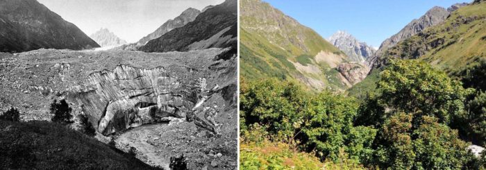
The Tviberi Glacier valley is located in the Svaneti Region – a historic province of the Georgian Caucasus. Between 1884 and 2011, climate change has led to a dramatic retreat of the ice in this valley. Other glaciers in the Greater Caucasus evolved in a similar way in past decades. We investigated glaciers and their changes both in-situ and with remote sensing techniques in the 53 river basins in the southern and northern slopes of the Greater Caucasus in order to analyze glacier dynamics in combination with climate change over the last decades…
Why are glaciers important for the Caucasus region?
On the one hand, in a high mountain system such as the Greater Caucasus, glaciers are the source of rivers through snow and ice melting. They are therefore an important source of water for agricultural production, for several hydroelectric power stations, for water supply, and for recreational opportunities. Also, the Greater Caucasus glaciers have a positive impact on the economy by being a major tourist attraction. The Svaneti, Racha and Kazbegi regions in Georgia welcome thousands of visitors each year.
On the other hand, glacier hazards are relatively common in this region, leading to major casualties. On the 20th September 2002, for example, Kolka Glacier (North Ossetia) initiated a catastrophic ice-debris flow killing over 100 people, and, on the 17th May 2014, Devdoraki Glacier (Georgia) caused a rock–ice avalanche and glacial mudflow killing nine people (Tielidze and Wheate, 2018).
Tviberi Glacier Degradation over the last century
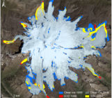
According to our investigation, the Tviberi was the largest glacier of the southern slope of Georgian Caucasus in the end of the 19th century with a total area of 49.0 km2. The glacier terminated at a height of 2030 m above sea level (a.s.l) in 1887 (based on topographical maps, see Fig.2a). Before the 1960s, the largest ice stream – the Kvitoldi Glacier – separated from the Tviberi, and became an independent glacier (Fig. 2b). The 1960 topographical map shows that, as a consequence, the Tviberi Glacier shrinked to an area of 24.7 km2 and the glacier tongue ended at 2140 m a.s.l. (Fig. 2b). Finally, the Landsat 2014 image shows the degradation of the Tviberi Glacier after 1960, as it decomposed into smaller simple-valley glaciers and even smaller cirque glaciers developed (Fig. 2c) (Tielidze, 2016).
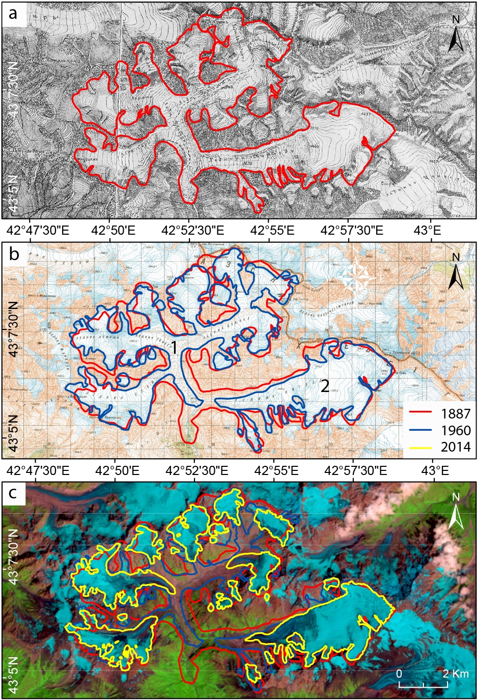
Fig.2: a – Tviberi Glacier, topographical map 1887; b – topographical map 1960, 1: Tviberi Glacier, 2: Kvitlodi Glacier; c – Landsat L8 imagery 2014. [Credit: modified from Fig.2 in Tielidzle, 2016]
Latest Caucasus Glacier Inventory
In our remote-sensing survey of glacier change in the Greater Caucasus based on large-scale topographic maps and satellite imagery (Corona, Landsat and ASTER), we show that the evolution of the Tviberi Glacier reflects the evolution of the majority of glaciers in the region. The main aim of this study was to present an updated and expanded glacier inventory at three time periods (1960, 1986, 2014) covering the entire Greater Caucasus (Russia-Georgia-Azerbaijan).
According to our study, glaciers on the northern slope of the Greater Caucasus lost 0.50% of their area per year between 1960 and 2014, while the southern slope glacier area decreased by 0.61% per year. Glaciers located on Mt. Elbrus lost 0.27% of their combined area per year during the same period. Overall, the total ice area loss between 1960 and 2014 was 0.53% per year, while the number of glaciers reduced from 2349 to 2020 for the entire Greater Caucasus (Fig. 3) (Tielidze and Wheate, 2018).
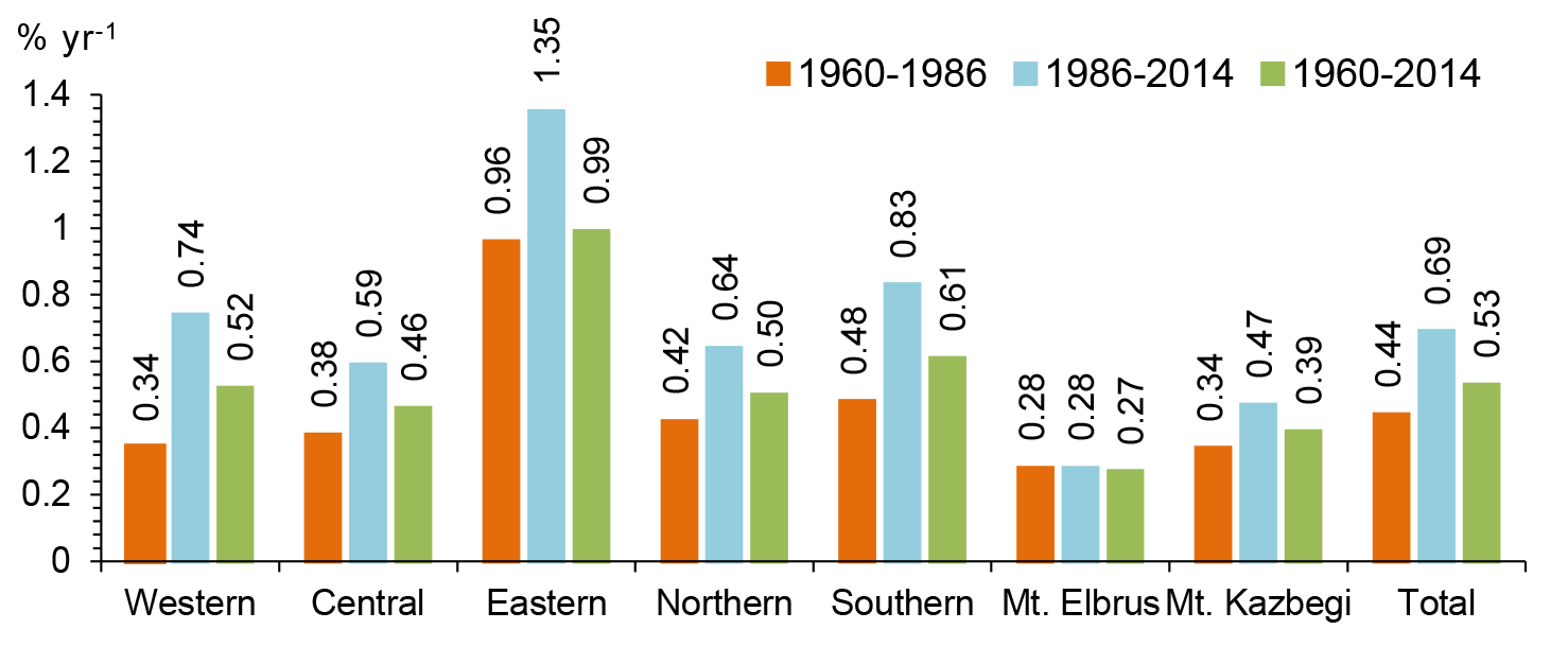
Fig.3: Greater Caucasus glacier area decrease by slopes, sections and mountain massifs in 1960–1986, 1986–2014 and 1960–2014 [Credit: Fig.4 in Tielidze and Wheate, 2018]
We have observed strong positive linear trends in the mean annual and summer air temperatures at all selected meteorological stations for the period 1960-2014 (Fig. 4). These climate data suggest that the loss of glacier surface area across the Greater Caucasus between the 1960 and 2014 mostly reflects the influence of rising temperatures in both the northern and southern slopes of the Greater Caucasus. The highest temperature increase was recorded in the eastern Greater Caucasus where the glacier recession was highest at the same time. If the decrease in the surface area of glaciers in the eastern Greater Caucasus continues over the 21st century, many will disappear by 2100 (Tielidze and Wheate, 2018).
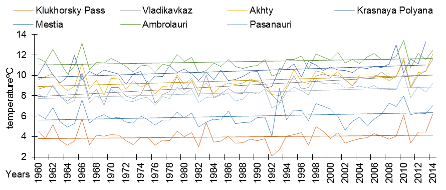
Fig.4: Mean annual air temperatures at the seven meteorological stations in the years 1960–2014. [Credit: Levan Tielidze]
Want to use these and more data?
This new glacier inventory has been submitted to the Global Land Ice Measurements from Space (GLIMS) database and can be used as a basis data set for future studies.
Further reading
- Tielidze, L. G. (2016). Glacier change over the last century, Caucasus Mountains, Georgia, observed from old topographical maps, Landsat and ASTER satellite imagery. The Cryosphere, 10(2), 713-725, doi: 10.5194/tc-10-713-2016.
- Tielidze, L. G., & Wheate, R. D. (2018). The Greater Caucasus Glacier Inventory (Russia, Georgia and Azerbaijan). The Cryosphere, 12(1), 81-94, doi: 10.5194/tc-12-81-2018.
Edited by Clara Burgard
 Levan Tielidze is a senior research scientist at Institute of Geography, Tbilisi State University. He is also a PhD student of School of Geography, Environmental and Earth Sciences, and Antarctic Research Centre at Victoria University of Wellington. The field of his research is modern glaciers and glacial-geomorphological studies of the mountainous areas in the Quaternary (Late Pleistocene and Holocene). Contact Email: levan.tielidze@tsu.ge/levan.tielidze@vuw.ac.nz.